Location and road description
Between Bruges and the Belgian coast
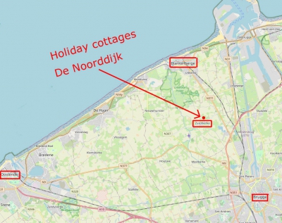
Address for sat nav (GPS)
- Country: Belgium
- Village: Zuienkerke
- Street: Blankenbergse Dijk Noord
- House number: 13

Distance to...
| Butcher | 330 m |
| Village shop | 350 m |
| Pub - Restaurant Boldershof | 500 m |
| The nature reserve Uitkerkse Polder | 3,50 km |
| Blankenberge Colruyt | 4,60 km |
| Bruges Carrefour | 5,00 km |
| Bruges Lunchgarden | 5,00 km |
| Lissewege | 5,40 km |
| Blankenberge railway station | 6,30 km |
| Blankenberge beach | 7,00 km |
| Bruges center | 8,70 km |
| Wenduine | 9,00 km |
| De Haan | 11,20 km |
| Zeebrugge | 11,60 km |
| Bruges railwaystation | 12,00 km |
| Damme | 13,70 km |
| Ostend | 19,90 km |
| Sluis - The Netherlands | 25,70 km |
Road description
- Road description Google maps
- Coming from the highway E40 take exit 'Brugge'.
- This leads you to the (N31/E403) from Brugge to Zeebrugge.
- Keep following the direction of Blankenberge.
- At the round-about continue to follow the direction Blankenberge
- After the bridge you arrive on the N371 (road from Brugge to Blankenberge).
- After approximately 2 km (1.25 miles) you turn left at the first traffic lights.
- At the beginning of the village you take the first on your right.
- After about 50 metre you find De Noorddijk on your right.